[Page 5] |
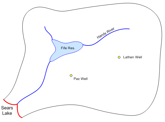
18. (39 pts) The following is a conceptual representation of Lost Valley. The site contains two wells, a river, and a small reservoir. It empties into a larger lake on the southeast corner of the site.
Click here to download a zip archive containing a copy of a GMS project file representing a starting point for this problem. Unzip the archive to a directory on a local drive. The project file contains two background image files. Open the lostvalley.gpr project in GMS and complete the following exercise. We will be building a single layer model. Save your results periodically in case you run into a problem.
Click here to download a copy of the solution.
You may use the GMS help utility with this problem.
a. (0.5 pts) Create a new MODFLOW conceptual model object called "lost valley".
b. (0.5 pts) Create a new coverage called "boundary" that has no properties. Create a set of arcs in this coverage corresponding to the outer boundary of the site to be modeled. Make a copy of this coverage as a starting point for each of the coverages you will be creating below.
c. (0.5 pts) Create a source/sink coverage for the lake (spec head), reservoir, river, and the two wells. Set up the appropriate attributes and create the points, arcs, and polygons.
i. (0.5 pts) Set the head = 649 m at the Sears Lake boundary.
ii. (3 pts) Set up the objects for Fife Reservoir using the following data:
Stage =665 m.
Reservoir bottom sediments:
Vertical thickness = 2 m
Vertical K = 0.01 m/dayiii. (3 pts) Set up the river arcs using the following data:
The river bottom sediments have the following characteristics:
Vertical thickness = 1 m
Vertical K = 0.1 m/day
Average river width = 3 mRiver stage and bottom elevation:
For the node attached to Sears Lake, use the lake stage (649 m).
For the nodes attached to Fife Reservoir, use the reservoir stage (665 m).
For the top of the short branch north of the reservoir, use a stage = 667 m.
For the top of the branch to the east of the reservoir, use a stage = 669.5.
Make the river bottom elevation equal to the stage minus 1.5 m in all cases.iv. (2 pts) Create the two wells as follows:
Paz Well: 3250 m^3/day extraction
Lathen Well: 1285 m^3/day extraction
d. (1 pt) Build a recharge coverage. Set the recharge rate = 0.0003 m/day.
e. (2 pts) Build a coverage for hydraulic conductivity. Turn on the other image to display the K zones. Assign the K values as follows:
Zone 1: K = 5 m/d
Zone 2: K = 1.5 m/d
Zone 3: K = 3 m/d
f. (0.5 pts) Create a grid frame and build a grid with 60 cells in the x-direction and 45 cells in the y-direction.
g. (0.5 pts) Initialize MODFLOW and activate the cells inside your conceptual model.
h. (0.5 pts) Map your conceptual model data to the MODFLOW grid.
i. (2 pts) The zip archive you downloaded included two text files containing scatter point elevation data. One for the top elevations (ground surface) and one for the bottom elevations (bedrock). Use the File/Open command to import the bedrock.txt and ground.txt files.
j. (2 pts) Interpolate from the bedrock scatter point set to the MODFLOW bottom elevations array. Interpolate from the ground scatter point set to the MODFLOW top elevations array.
k. (0.5 pts) Assign an appropriate starting head value to the entire grid.
l. (0.5 pts) Save and run your MODFLOW model. Read in the solution and make sure the heads look reasonable.
(Upload instructions and links went here)