[Page 5] |
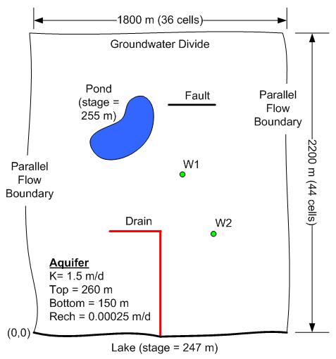
30. (modflow) The following is a conceptual model representation of a site. The site to be modelled is approximately rectangular in shape and is bounded on the top by a groundwater divide, on the left and right by parallel flow boundaries, and on the bottom with a large lake. There is a small irrigation pond in the interior of the model along with a low-permeability fault, an agricultural drain, and two small wells named W1 and W2.
Assume the following properties:
Drain:
K = 0.05 m/d
Average drainage length (from aquifer to drain) = 0.5 m
Average drain width = 1.0 m.
Average drain elevation = 247 m
Pond Sediments:
K = 0.002 m/d
Average drainage length (from pond to aquifer) = 2.0 m
Wells:
W1: Q = -300 m3/d
W2: Q = -200 m3/d
Fault:
Width: 1 m
K: 0.0001 m/d
Click here to download a copy of a GMS project file representing a starting point for this problem. The project file contains graphical objects representing each of the primary features of the site. Open the project file in GMS and build a one-layer MODFLOW model based on the description above. Use the lower-left corner of the grid as the original of your local coordinate system. Save your model frequently throughout the exercise so you don't lose your work if something happens.
Click here to download a copy of the solution.
Grading:
(a) Grid with the proper dimensions and number of cells.(2 pts)
(b) Units and selection of packages. (1 pt)
(c) Array values for starting heads, top and bottom elevations, K, and recharge. (5 pts)
(d) Boundary conditions on perimeter of model. (2 pts)
(e) Drain. (4 pts)
(f) Pond. (4 pts)
(g) Wells (2 pts)
(h) Fault (3 pts)
(Upload instructions and links went here)